
DEEP SOUTH DIVERS Finds Sunk Boat
We received a phone call from a shrimp boat captain that had a problem: He had shrimped all day, then anchored his small vessel (this one an unusually small 30-footer) in the Port Royal Sound, right outside of Skull Creek, near the northwestern tip of Hilton Head Island. He had had a particularly good catch and decided to bed down for the night onboard so that he could get a very early start the next morning.
Sometime during the middle of the night, his boat became swamped and it began to sink. He awoke when the water sloshed up against his cot and wet his face. The boat was already too swamped to pump out, and it went down, right at anchor, at about 4am. The captain swam for another nearby boat, and was rescued.
He asked us to locate the boat and salvage it. He had a general idea of where to look, but no coordinates, since the boat's electronics - and it's data - had gone down with the vessel.
It took us two days of work - separated by about a week for a passing hurricane, making weather an issue - to locate the sunk boat. We used his first-hand account, the neighboring boat's approximate coordinates, and our advanced, WAAS-enabled LOWRANCE side scan unit. Here's what we saw when we finally passed over the vessel during our "mow the lawn" searches: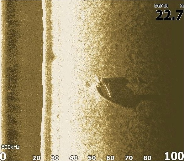
Keep in mind that this is a birds-eye view of the vessel sitting on the bottom of the Port Royal Sound... Basically, a two-dimensional image, looking straight down as if you were floating on the top of the water like a snorkeler. Side scanning sonar uses sound waves to create this image, since the water was too murky to allow light to pass through. When looking at this image, know that side scan sonar "lights up" an image from the side... Creating a shadow effect on the seabed that stretches outward (to the right in this case) from the sunk vessel. We use this to "read" how tall something is, and what shape it is. Here's a closer look:
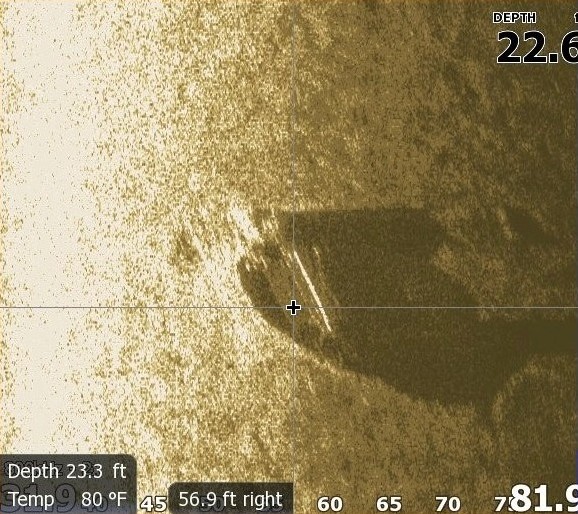
Notice the overall shape of the vessel - basically set on the bottom in such a way that the stern (rear) of the vessel points toward the top left of the image, while the bow (front) of the vessel points toward the bottom right. The whiteish thing sticking off of the vessel's stern (what we call a "hard return" - a very bright echo of sound) is the boat's outdrive (propeller and steering mechanisms). From the vessel's shadow it can be deduced that there is a large boxlike structure on the stern (a steel frame used to lift and haul nets full of shrimp) and an enclosure (the wheelhouse) near the bow. In fact, the bow pulpit (like a plank sticking off the bow's point, where an anchor is held) is actually visible in the shadow.
LOWRANCE side scan sonar (they call it "StructureScan") allows us to create a unique view of this vessel as it might appear if you viewed it from the bottom... That is, if you were diving and laying on the bottom, looking forward at the vessel. This viewpoint might be more familiar to those who are accustomed to seeing traditional "depth sounders" or "fish finders" - a side view rather than a top-down view:
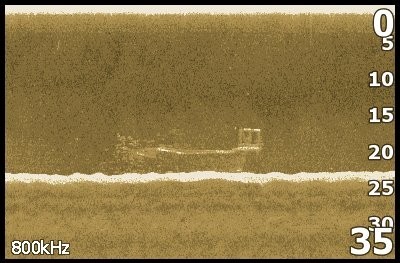
The "box" on the stern of the vessel (right side, above) is even more discernable in this image. The "cloud" surrounding the bow (left side) is a school of fish that had already made this wreck their home.
After pricing the job and giving a bid to the sunk vessel's captain, he elected not to raise it, even though it was possible and we cut our prices as low as we could go. He did, however, elect to have us salvage all things of value off of his boat: The nets, tools, electronics, personal artifacts, etc., which he valued at about $3,000 (the majority of which was the cost of the nets). He has since purchased a new vessel (which cost about the same as our bid to raise his old one) and is shrimping today.
Today the old boat is quickly becoming a new artificial reef, and has attracted a ton of sea life.